
See a map of the Cairo area at this time
|
A little Islamic history to provide the background for the next stage of the history of Cairo: The Caliphs who ruled the Muslim world from their capital in Damascus were called the Ummayads, and they managed to hold power for a little more than one hundred years, from roughly the 630s until about 750. After that, a new dynasty rose to the east, in Baghdad, and they were called the Abbassids. The Abbassids sent a new governor to Egypt to build a new city, called Medinat al-Askar, or 'City of Canonments.' The new city, built to the north of al-Fustat was supposed to replace that city, but failed to do so. Today, there is little left of Medinat al-Askar. In the mid-9th century CE, there was a lot of intrigue going on at the Abbassid court. Most of it does not have too much to do with our story, but you need to know a few things in order to understand what happens next. Since they came to power, the Abbassids had been in the habit of recruiting Turks as officers in their armies. "Recruiting" is a nice way of saying that the Abbassids took the Turks as slaves, taught the Turks how to be good soldiers, and then set them free. The Abbassids thought that the Turks would be so grateful that they the Turks would do anything the Caliph asked. This system never worked the way that the Abbassids intended, since the one thing the Turks had learned while they were slave officers-in-training is that if you want to get anything done, you need to have power. The Turks soon became politically very powerful, and began to influence Abbassid politics. The Abbassids, who had not expected this, were not pleased with this new situation. One of the ways the Abbassids dealt with this was to appoint some of the more influential (another way of saying "troublesome") Turks as governors to the far-flung provinces of the empire. This made the Turks feel important and got them out of the capital, which made the Abbassids happy. Unfortunately for the Abbassids, the Turks caught on after a while, and began sending family members in their place to serve as governors of these provinces, while they themselves remained at the Caliph's court. One such influential Turk was a man by the name of Bayikbey, whom the Caliph particularly disliked and feared. In 868 CE, the Caliph offered to make Bayikbey governor of Egypt. Bayikbey decided to send his son-in-law, a man by the name of Ahmed Ibn Tulun to rule Egypt instead. Ahmed took his family and a force of soldiers, and went off to Egypt. As a footnote to the story, the Caliph was not at all pleased that Bayikbey was still around, and had him killed. When Ibn Tulun got to Egypt, he found that Fustat wasn't large enough to house his armies. He set about building yet another city. He selected a site a little to the north of Medinat al-Askar, and began building a city he called Medinat al-Qatta'i, or "City of Sections." The city got this name because it was laid out in a grid-like pattern that lent itself very nicely to being subdivided up into separate sections for the military officers, the soldiers, the merchants, the traders, and other groups. Why Did They Keep Going North? Al-Fustat was first. Then came Medinat al-Askar, and it was built to the north of al-Fustat. Then along came Ibn Tulun, and he built Medinat al-Qatta'i to the north of Medinat al-Askar. In the next lesson, we will see that the Fatimids built Medinat al-Qahira to the north of Medinat al-Qatta'i. So why does everyone keep going north? There is a simple answer to this question. Despite the fact that it grew to be really large and prosperous, al-Fustat was not located in an ideal position. This has to do with physical geography. Al-Fustat was built adjacent to the existing settlement of Babylon, but the hills to the east prevented breezes from reaching the city. The city was built on a low-lying plain, meaning that walls had to be built and constantly maintained in order to prevent the Nile from flooding the city every year. When the Nile receded, it would leave large pools of water lying around that were perfect breeding grounds for really large mosquitoes that often carried malaria and other diseases. Sounds nice, doesn't it? There are two reasons everyone kept going north. First, there were high plains to the north that kept the flood waters out and the mosquitoes to a minimum. Second, the main wind came from the north, meaning that the town garbage dump was usually situated to the south of town. Therefore, if you wanted clean smelling air, you built to the north and put your garbage dump on the south side of town, so that the wind would carry the smell away from town. It worked great if you lived in one of the new settlements, not so great if you lived in one of the old settlements, downwind of the garbage dumps. Al-Fustat flourished until the 11th century CE, by which time there were three towns to the north of it. Can you imagine what that must have smelled like? Ibn Tulun was not much more interested in being governor of Egypt than his father-in-law had been, but this was because Ibn Tulun did not want to serve anyone else. Ibn Tulun's idea was to break away from the Abbassids and run Egypt as his own private kingdom. One way he showed that he was independent of the Abbassids was building al-Qatta'i to be a lavish and exquisite new city that would rival the new Abbassid capital, Samarra. In order to accomplish this, he built a large new mosque in the center of town that he named after himself. He also built a large palace, a hippodrome (race course), gardens, a large and renown hospital, or bimaristan, and a large shopping area, or suq. The mosque that Ibn Tulun built is still one of the largest and oldest in the entire Muslim world. It was built over three years, from 876 to 879 C.E. It covers an area of over 80,000 square feet. The outer walls extend for nearly 525 feet on each side, and are over 40 feet high. It can hold over 800 people in the vast courtyard inside. Learn More about Mosques A mosque is a building where Muslims gather to pray, but also to meet each other, especially during the holy month of Ramadan, and on the holidays of Eid al-Fitr, which comes at the end of Ramadan, on Eid al-Adha, the Day of Sacrifice, and on other occasions. It was also the place to get an education about religious scripture, rather like Sunday school or Torah school. A mosque should not be thought of as the Islamic equivalent of a church, because the institutions are different. A Muslim who cannot make it to a mosque on Friday (which is the holy day) can pray at home. The prayer leader, called an imam, is also not the same as a Christian priest or Jewish rabbi. Though there are imams who go to school to learn religious scripture and law, any adult Muslim who knows the Qur'an can act as imam at prayer time. Often, when praying at home, the mother or father will act as imam for the family. The basic design of the mosque reflects the home of Muhammad in Mecca. Muhammad's house, like many in Arabia, consisted of many rooms that opened onto a central courtyard where people would gather. There were no seats � everyone stood, or sat on the ground. Some people would carry rugs with them to sit on. Mosques are the same way. Most mosques have a large open room reserved for prayer. At the front of the room (called the qibla side) is a niche called a mihrab, which shows the exact direction of the city of Mecca. All Muslims are supposed to pray facing Mecca five times a day. In many mosques, there is an elevated podium called a minbar, which lets the imam get up high so that everyone can see and hear him lead the prayer. Many mosques have tall towers called minarets that let announcers (called muezzins) call out that it is time for prayer. Many mosques also have fountains, because Muslims are supposed to wash their hands and feet before going to pray. Many older mosques also have tablets that record who built the mosque and when it was built. Can you identify these features on the Mosque of Ibn Tulun? The Mosque of Ibn Tulun |
) 1) The central fountain and the |
) 2) The large courtyard, which can accommodate thousands of workshippers. |
) 3) The cupola over the minbar allows natural light to enter the mosque. |
) 4) Close up of the central abolutions fountain that worshippers use to wash before prayer. |
) 5) Detail of the interior of the mosque, with the repeating geometric designs of the arches that are common in Islamic architecture. |
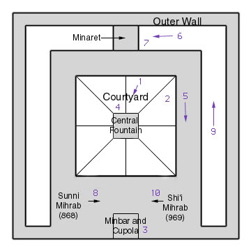 Map of the Mosque of Ibn Tulun. The numbers correspond to the photographs in this section. Arrows indicate which direction the photographer is facing. |
) 6) The minaret of the mosque was added by the Fatimids, as can be seen in the North African design of the minaret. |
) 7) Close up of the minaret with its North African architectural features. |
) 8) When the mosque was originally commissioned in 868, the original mihrab was this dedication identifying who built the mosque and offering the Sunni Muslim profession of faith. |
) 9) The space between the interior and exterior walls of the mosque. Many doors led into the mosque compound, allowing everyone to enter for Friday prayers. |
) 10) When the Faitimids founded al-Qahira in 969, they rededicated the mosque according to their Shi'i beliefs, and placed a new mihrab with the Shi'i profession of faith inscribed upon it. |
|
Ibn Tulun lived until the year 883, and he was known as a kind, wise, and generous ruler. He was succeeded by his son, Khumarraweh, who, though kind and generous, was also known to be something of a fool. He was murdered in 895, and his sons who succeeded him were fairly useless. In 905, the Caliph sent troops to reclaim Egypt for the Abbassids under the leadership of Suleiman al-Katib. Suleiman destroyed most of al-Qatta'i, except for the magnificent mosque. He also did what Ibn Tulun had done before him; he took over Egypt and ruled it as his own. Suleiman sent a yearly tribute to the Caliph as a bribe to keep him happy, and he and his sons ruled Egypt until the year 969, when a more powerful force came in from the west. All photographs copyright 1995 by Christopher Rose. |