|
THE
BASICS OF WEATHER RADAR | GOES-8 AND GOES-10
POLAR-ORBITING SATELLITES | HOW
SATELLITES ARE NAMED
NOAA'S
GEOSTATIONARY AND POLAR-ORBITING WEATHER SATELLITES
Operating the country's
system of environmental ( weather ) satellites is one of the major
responsibilities of the National Oceanic and Atmospheric Administration's
(NOAA's) National Environmental Satellite, Data, and Information
Service (NESDIS). NESDIS operates the satellites and manages the
processing and distribution of the millions of bits of data and
images theses satellites produce daily. The primary customer is
NOAA's National Weather Service, which uses satellite data to
create forecasts for the public, television, radio, and weather
advisory services. Satellite information is also shared with various
Federal agencies, such as the Departments of Agriculture, Interior,
Defense, and Transportation; with other countries, such as Japan,
India, and Russia, and members of the European Space Agency (ESA)
and the United Kingdom Meteorological Office; and with the private
sector.
NOAA's operational
weather satellite system is composed of two types of satellites:
geostationary operational environmental satellites (GOES) for
short-range warning and "now-casting" and polar-orbiting satellites
for longer-term forecasting. Both kinds of satellite are necessary
for providing a complete global weather monitoring system.
A new series of GOES
and polar-orbiting satellites has been developed for NOAA by the
National Aeronautics and Space Administration (NASA). The new
GOES-I through M series provide higher spatial and temporal resolution
images and full-time operational soundings. The polar-orbiting
meteorological satellites (beginning with NOAA-K in 1998) will
provide improved atmospheric temperature and moisture data in
all weather situations. This new technology will help provide
the National Weather Service the most advanced weather forecast
system in the world.
Geostationary Operational
Environmental Satellites (GOES) GOES satellites provide the kind
of continuous monitoring necessary for intensive data analysis.
They circle the Earth in a geosynchronous orbit, which means they
orbit the equatorial plane of the Earth at a speed matching the
Earth's rotation. This allows them to hover continuously over
one position on the surface. The geosynchronous plane is about
35,800 km (22,300 miles) above the Earth, high enough to allow
the satellites a full-disc view of the Earth. Because they stay
above a fixed spot on the surface, they provide a constant vigil
for the atmospheric "triggers" for severe weather conditions such
as tornadoes, flash floods, hail storms, and hurricanes. When
these conditions develop the GOES satellites are able to monitor
storm development and track their movements.
GOES satellite imagery
is also used to estimate rainfall during the thunderstorms and
hurricanes for flash flood warnings, as well as estimates snowfall
accumulations and overall extent of snow cover. Such data help
meteorologists issue winter storm warnings and spring snow melt
advisories. Satellite sensors also detect ice fields and map the
movements of sea and lake ice.
NASA launched the
first GOES for NOAA in 1975 and followed it with another in 1977.
Currently, the United States is operating GOES-8 and GOES-10,
launched in 1997. GOES-9 (which malfunctioned in 1998) is being
stored in orbit to replace either GOES-8 or GOES-10, should either
fail.
GOES-8
AND GOES-10
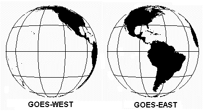
The United States
normally operates two meteorological satellites in geostationary
orbit over the equator. Each satellite views almost a third of
the Earth's surface: one monitors North and South America and
most of the Atlantic Ocean, the other North America and the Pacific
Ocean basin. GOES-8 (or GOES-East) is positioned at 75 W longitude
and the equator, while GOES-10 (or GOES-West) is positioned at
135 W longitude and the equator. The two operate together to produce
a full-face picture of the Earth, day and night. Coverage extends
approximately from 20 W longitude to 165 E longitude. This figure
shows the coverage provided by each satellite.
The main mission is
carried out by the primary instruments, the Imager and the Sounder.
The imager is a multichannel instrument that senses radiant energy
and reflected solar energy from the Earth's surface and atmosphere.
The Sounder provides data to determine the vertical temperature
and moisture profile of the atmosphere, surface and cloud top
temperatures, and ozone distribution. Other instruments on board
the spacecraft are a Search and Rescue transponder, a data collection
and relay system for ground-based data platforms, and a space
environment monitor. The latter consists of a magnetometer, an
X-ray sensor, a high energy proton and alpha detector, and an
energetic particles sensor. All are used for monitoring the near-Earth
space environment or solar "weather."
| GOES-10
Characteristics |
| Main body: |
2.0m (6.6 ft) by 2.1m (6.9
ft) by 2.3m (7.5 ft) |
| Solar array: |
4.8m (15.8 ft) by 2.7m
(8.9 feet) |
| Weight at liftoff: |
2105 kg (4641 pounds) |
| Launch vehicle: |
Atlas I |
| Launch date: |
April 25, 1997 Cape Canaveral
Air Station, FL |
| Orbital information: |
Type: Geosynchronous
Altitude: 35, 786 km (22, 236 statute miles)
Period: 1,436 minutes
Inclination: 0.41 degrees |
| Sensors: |
Imager
Sounder
Space Environment Monitor (SEM)
Data Collection System (DCS)
Search and Rescue (SAR) Transponder |
The
United States reaps many benefits from the new series of GOES
satellites as they aid forecasters in providing better advanced
warnings of thunderstorms, flash floods, hurricanes, and other
severe weather. The GOES-I series provide meteorologists and
hydrologists with detailed weather measurements, more frequent
imagery, and new types of atmospheric soundings. The data gathered
by the GOES satellites, combined with that from new Doppler
radars and sophisticated communications systems make for improved
forecasts and weather warnings that save lives, protect property,
and benefit agricultural and a variety of commercial interests.
For
users who establish their own direct readout receiving station,
the GOES satellites transmit low resolution imagery in the WEFAX
service. Highest resolution Imager and Sounder data is found
in the GVAR primary data user service.
POLAR-ORBITING
SATELLITES
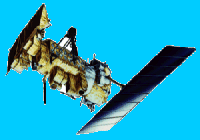
Complementing
the geostationary satellites are two polar-orbiting satellites
known as Advanced Television Infrared Observation Satellite
(TIROS-N or ATN), constantly circling the Earth in an almost
north-south orbit, passing close to both poles. The orbits are
circular, with an alitude between 830 (morning orbit) and 870
(afternoon orbit) km, and are sun synchronous. One satellite
crosses the equator at 7:30 a.m. local time, the other at 1:40
p.m. local time. The circular orbit permits uniform data acquisition
by the satellite and efficient control of the satellite by the
NOAA Command and Data Acquisition (CDA) stations located near
Fairbanks, Alaska and Wallops Island, Virginia. Operating as
pair, these satellites ensure that data for any region of the
Earth are no more than six hours old.
A suite
of instruments is able to measure many parameters of the Earth's
atmosphere, its surface, cloud cover, incoming solar protons,
positive ions, electron-flux density, and the energy spectrum
at the satellite altitude. As a part of the mission, the satellites
can receive, process and retransmit data from Search and Rescue
beacon transmitters, and automatic data collection platforms
on land, ocean buoys, or aboard free-floating balloons. The
primary instrument aboard the satellite is the Advanced Very
High Resolution Radiometer or AVHRR.
| NOAA-15
Characteristics |
| Main body: |
4.2m (13.75 ft) long, 1.88m
(6.2 ft) diameter |
| Solar array: |
2.73m (8.96 ft) by 6.14m
(20.16 ft) |
| Weight at liftoff: |
2231.7 kg (4920 pounds)
including 756.7 kg of expendable fuel |
| Launch vehicle: |
Lockheed Martin Titan II |
| Launch date: |
May 13, 1998 Vandenburg
Air Force Base, CA |
| Orbital information: |
Type: sun synchronous
Altitude: 833 km
Period: 101.2 minutes
Inclination: 98.70 degrees |
| Sensors: |
Advanced Very High Resolution
Radiometer (AVHRR/3)
Advanced Microwave Sounding Unit-A (AMSU-A)
Advanced Microwave Sounding Unit-B (AMSU-B)
High Resolution Infrared Radiation Sounder (HIRS/3)
Space Environment Monitor (SEM/2)
Search and Rescue (SAR) Repeater and Processor
Data Collection System (DCS/2) |
The
polar orbiters are able to monitor the entire Earth, tracking
atmospheric variables and providing atmospheric data and cloud
images. They track weather conditions that eventually affect
the weather and climate of the United States. The satellites
provide visible and infrared radiometer data that are used for
imaging purposes, radiation measurements, and temperature profiles.
The polar orbiters' ultraviolet sensors also provide ozone levels
in the atmosphere and are able to detect the "ozone hole" over
Antarctica during mid-September to mid-November. These satellites
send more than 16,000 global measurements daily via NOAA's CDA
station to NOAA computers, adding valuable information for forecasting
models, especially for remote ocean areas, where conventional
data are lacking.
Currently,
NOAA is operating two polar orbiters: NOAA-14 launched in December
1994 and a new series of polar orbiters, with improved sensors,
which began with the launch of NOAA-15 in May 1998. NOAA-12
continues transmitting APT and HRPT data as a stand-by satellite.
For
users who want to establish their own direct readout receiving
station, low resolution imagery data is available in the Automatic
Picture Transmission (APT) service, while the highest resolution
data is transmitted in the High Resolution Picture Transmission
(HRPT) service.
HOW
SATELLITES ARE NAMED
NOAA
assigns a letter to the satellite before it is launched, and
a number once it has achieved orbit. For example, GOES-H, once
in orbit, was designated GOES-7, GOES-G, which was lost at launch,
was never assigned a number. The same system is used for polar
orbiters; for example, NOAA-11, still in orbit, was designated
NOAA-H before launch. NOAA-J became NOAA-14.
-top-
|